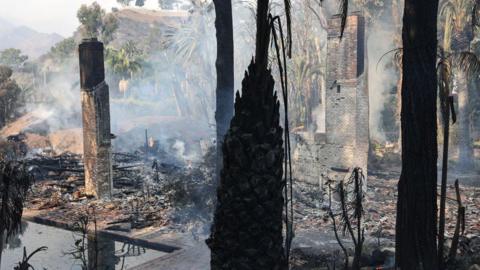
Malibu city authorities initially said the fire was about three miles (4.8km) north of the Pacific Coast Highway (PCH) - an iconic road along the Pacific Ocean known for its stunning views - but it quickly spread south, jumping across the route into the Malibu Pier area.
The evacuation order covered a region that included east of Malibu Canyon Road and south of Puma Road as well as the Serra Retreat area, the County of Los Angeles Fire Department said.
A map of the blaze shows it was bordering city hall government facilities, a school and a number of homes in the area - including a line of oceanfront properties.
In an update on Tuesday night, officials said they had to move the command centre to the city of Calabasas, after city hall was threatened by the flames.
Officials warn that the fires are being fuelled by the seasonal Santa Ana winds.
The latest incident comes about a month after another fire forced thousands of people to evacuate another nearby city, Moorpark.
California is a state that is prone to wildfires. The amount of burned areas in the summer in northern and central part of the state increased fivefold from 1996 to 2021 compared with the 24-year period before.
Scientists have attributed this to climate change, though not all wildfires can automatically be linked directly to this cause.
The science is complicated and human factors, including how we manage land and forests, also contribute.
However, scientists say climate change is making weather conditions that lead to wildfires, such as heat and drought, more likely.